|
|
 |
Evidence on performance Nuremberg, Germany Danish EMIL Project San Diego, US Local towns, UK Gaps and weaknesses Nuremberg, Germany Context By the end of the 1980s it was still possible to travel through the town centre in a north-south direction and vice versa. The 1991 plan determined that no motor vehicle traffic through the centre would be possible. But the results of the 1991 plan have not been reported. Impacts on demand Nuremberg started with a very large pedestrianisation scheme. When it become clear that little increase in traffic flows occurred in the parallel roads, the city become more and more confident over the years that a substantial reduction in motor vehicle traffic in the city centre, and also in some of the inner city areas, was the right way forward. Impacts on supply
Contribution to objectives
Context The subject of the project was the ‘environmentally adapted through road’, which also included a close monitoring of the effects of the implemented traffic calming measures. Three towns were chosen, representing different problems of small towns with through traffic. In Vinderup (3,000 inhabitants) the through road is also the shopping streets of the town, in Skaerbaek (4,000 inhabitants) the through road intersects the shopping street and in Ugerlose (1,000 inhabitants) the through road takes a more winding route. The measures used differed slightly from town to town, but the general design was similar. At the approach to the town rumble strips were installed, followed by a gate situation created by trees and in one case by a road narrowing. Within the town (from gate to gate) separate cycle tracks and pavements were provided on both sides of the road; pinch points and, chicanes served as speed-reducing measures. In addition, trees were planted. Impacts on demand
A reduction in motor vehicle traffic was achieved only in Skaerbaek, with it increases in Ugerlose and Vinderup in no special reasons were given. The speed limit on the through roads in all three towns was 60 km/h before the project started, which is high for a built-up area. The after research was carried out when the speed limit was still 60 km/h but it was later reduced to 50 km/h in all three towns. Automatic speed measurements showed speeds to have decreased slightly in all three towns by between five and eight km/h. The delays caused to motor vehicles by the speed-reducing measures were calculated to be between seven and ten seconds per km. Impacts on supplyRoad capacity for vehicle use was reduced by traffic calming measures such as road narrowing and pinch points and also by providing cycle lane. Contribution to objectives
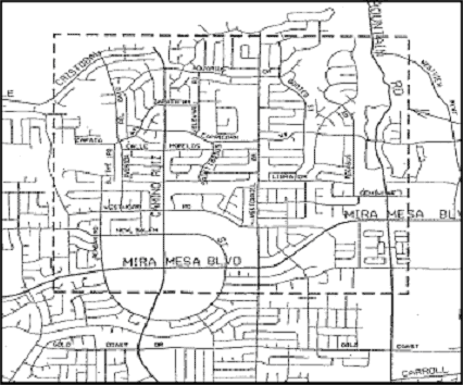
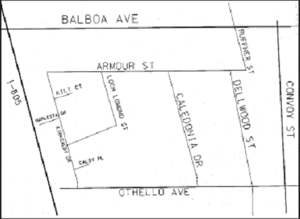
San Diego, US Context Ewing (1999) reports the effective and ineffective choices of traffic calming measures in San Diego. Figure1 Street network inviting through-traffic at Mira Mesa in San Diego (Ewing, 1999) Vehicle users pass Mira Mesa streets to travel between inland and coastal communities (see Figure 1). There are few east-west arterials in that part of San Diego, and those few had become congested enough to cause vehicle users to divert to alternative routes. Five residential collectors had become problematic, affected not only by high traffic volumes but also by the excessive speeds that often accompany through traffic. At the request of the Mira Mesa Community Planning Committee, the city first tried peak-hour turn restrictions to discourage shortcutting. The restrictions did not work. Vehicle users found ways to circumvent them through U-turns and other manoeuvres. The city then installed speed humps. The hump profile chosen was the 12-foot parabolic hump. Figure2 Street network inviting through-traffic at Royal Highlands in San Diego (Ewing, 1999) The Royal Highlands neighbourhood, sandwiched between two arterials and a freeway in San Diego, also had a through traffic problem (see Figure 2). Traffic would filter through the neighbourhood on one of four local residential streets. The first attempt at traffic calming was the installation of 12-foot speed humps. While closely spaced and severe in profile, the humps were not sufficient to counter the strong incentive to cut through the neighbourhood. Then further traffic calming, full road closures, was also implemented. Impacts on demandThe humps in Mira Mesa were successful in the limited sense of reducing through traffic on four collectors and reducing vehicle speeds on all five (Table 1). However, they were not successful in a more general sense because new problems were created. Fire response times were degraded by the treatment of Capicorn Way. Traffic was diverted from collectors to parallel local streets that were less well designed to deal with it. The one local street for which before-and-after data were available experienced a 34 percent rise in traffic volume and a nine percent increase in its 85th percentile speed. Table1: Traffic on collectors before and after speed hump installation in Mira Mesa (Ewing, 1999)
The main effect of the humps of the first attempt in the Royal Highlands was to divert traffic to the local street closest to the neighbourhoods northern entry point, Dellwood Street. The Dellwood route offered the fewest humps end-to-end. However, the second attempt was more successful. After closing the northern entry point at Armour Street, traffic volumes on all local streets fell below their initial levels. The neighbourhood now has speed controls (which did not solve the through traffic problem) and a volume control (which apparently was effective). Table2 Traffic before humps, after humps, and after closure in Royal Highlands (Ewing, 1999)
Impacts on supply In the case of Royal Highlands, road capacity was reduced by half due to the closures implemented in Armour Street. Contribution to objectives
Local towns, UK Context The County Surveyors Society (1994) reviewed 152 case studies and provided more detail of the 85 case studies of traffic calming implemented in the late 1980s and early 1990s in the UK. The numerical analysis which follows draws on all the 152 case studies submitted. Just over half the schemes (56%) were located in urban residential area with 29% occurring on main roads in rural locations and the remaining 15% in town centre areas. 74% of the schemes were aimed at reducing speed, with 64% aimed at accident reduction, and 36% at reducing the volume of through traffic. Nearly every scheme was intended to address two of these problems and many were aimed at all three. Environmental improvements were sought in 17% of the schemes, fairly evenly spread over the three types of location. 76% of the schemes used more than one type of speed controlling device. Some schemes involved a whole range of different types of measures. Road humps in one form or another were included in 66% of the schemes submitted and were by far the most commonly used technique. The next most popular technique was some form of carriageway narrowing, with 41% of schemes using this method. Chicanes featured in 26% of schemes and 17% of the schemes included refuges, mini roundabouts, road markings and signs. Other relatively commonly used measures were gateways (10%), table junctions (9%), coloured surfacing and rumble strips (6%). Impacts on demandThe following table gives example results in the case studies for Town Centre Areas.
Note: Comparative subjective comments are given regarding effectiveness. These are based on the following indicative criteria which may differ from individual authorities own criteria options: Effectiveness should be assessed against the scheme objectives which can vary greatly. However, the effectiveness of the measures employed seems to vary considerably and it is not certain whether this is the result of differences in design or of location. From the schemes sent in was in not possible to identify any one specific measures as more or less effective. Effectiveness, it seems, will depend on the way measures are fitted to local conditions and on the combination of measures used (County Surveyors Society, 1994). Single measures were judged as of moderate cost of £3,000-£10,000, reasonable of £10,000-£20,000 and expensive over £20,000. For several measures moderate cost were £5,000-£50,000/km, reasonable were £50,000-£100,000/km and expensive over £100,000/km. Impacts on supplyMost schemes reduced road capacity for vehicle use and also limited vehicle speed. Contribution to objectives
There is limited evidence on impacts on public transport, especially bus services. If journey times on a bus route passing through traffic calmed streets are increased significantly because of the implemented measures, this will reduce the attractiveness of the service.
Text edited at the Institute for Transport Studies,
University of Leeds, Leeds LS2 9JT
|
|||||||||||||||||||||||||||||||||||||||||||||||||||||||||||||||||||||||||||||||||||||||||||||||||||||||||||||||||||||||||||||||||||||||||||||||||||||||||||||||||||||||||||||||||||||||||||||||||||||||||||||||||||||||||||||||||||||||||||||||||||||||||||||||||||||||||